
An application for a rezoning map amendment has been submitted for a proposed hyperscale data center in Mason County. The application is requesting an existing 2,080 acres of A-2 agricultural land to be rezoned to I-3 industrial.
“The proposed Project is designed to be harmonious with the surrounding environment and complies with the Comprehensive Plan,” the application stated. “As the physical embodiment of the Cloud, the proposed Project represents an opportunity for Mason County to meet modern computing power demands while securing long-term economic stability for the Mason County community.”
The application further expressed that the proposed project will diversify Mason County’s economic base by incorporating “Cloud computing technologies.”
“The Project will support a variety of job types, including technical operators, electrical, air condition and hearing specialists, logistics staff, security, and more,” it explained. “Kentucky has embraced the tech sector with the construction of the electric vehicle’ and battery manufacturing facilities, and leveraging technology for innovations in the bourbon and healthcare industries, among others.”
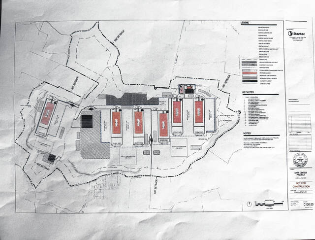
Hyperscale development plan
The application’s development plan depicts six proposed buildings, each having its own mechanical yard, industrial water tank, industrial wastewater tank, fire pump station, mechanical equipment pads and client load substation, which encompass approximately 3.4 acres each.
Several detention ponds are depicted as being located at varying points across the proposed site.
Three utility load substations are depicted on the southern side of the “campus,” with the largest one estimated to encompass 29.2 acres.
On the northeastern side of the proposed site, two buildings (Building A and Building B) are depicted adjacent to a parking lot.
Berms are depicted on the western and southwestern portions of the proposed site.
Site grading
According to the application, the proposed project plan requires site grading, which will support “required environmental and public-safety objectives,” and “create a functional site that meets the development standards outlined in the local ordinances.”
“The grading design was developed with the goal of balancing cut and fill across the site, reducing the need for importing or exporting soil. Existing topography was compared with proposed grades to align areas of excavation with areas requiring fill,” the application stated. “Building pad elevations, roadway profiles, and drainage features were adjusted to support this balance while maintaining functional site drainage and accessibility. Through iterative refinement, the grading plan achieves a near-neutral earthwork condition, promoting cost efficiency and minimizing off-site material handling.”
The application further notes that, should the project go forward, construction will occur in phases, with the grading to ensure “orderly construction, stable interim conditions, and continuity between successive phases.”
Stormwater ponds
According to the application, the proposed data center site is located in the Ohio River Watershed along a boundary between the Lawrence Creek and Lee Creek sub-watersheds.
“Due to the scope of this project, and the immense size of the required stormwater ponds, triggers for dam permitting under Kentucky Revised Statutes Chapter 151 had to be considered,” the application stated. “Stormwater ponds were designed with a maximum height of less than 25 feet from the toe of slope to the top of embankment elevation. Large drainage areas that would result in a required storage volume exceeding 50 acre-feet were broken up and routed to smaller regional ponds.”
Fifteen ponds are proposed in the application, with the largest drainage area measuring 94 acres. A proposed stormwater management system would limit post-development peak flowrates, provide a foot of freeboard, limit the height of embankment from the toe of the slope and capture runoff.
Project landscape
A landscape narrative included in the application expressed that the proposed project would incorporate internal site landscaping, open space areas and vegetative screening.
“The net site area is approximately 1,975 acres, or 86,031,000 square feet,” the application stated. “Landscaping adjacent to building foundations will primarily consist of rock mulch planting beds to facilitate ease of maintenance. Select building entrances and signage areas will include enhanced landscaping with woody shrubs and perennial plantings within a combination of rock mulch and wood mulch planting beds.”
Native seeds mixtures and varying tree species would be chosen to be distributed around 12,843 linear feet of earthen berms.
Noise modeling
According to the application, noise measurements have been modeled and tested, with the nearest residence located approximately 50 feet from the southern boundary of the proposed site.
“To characterize the ambient sound levels in the vicinity of the Site, Ramboll collected sound level measurements for one 48-hour period from Tuesday, November 18 to Thursday, November 20, 2024,” the application explained.
Three sound level measurements (SLM) locations collected data over a 48-hour period. According to the study’s findings, the observed noise source for all three SLMs was traffic, with the highest recorded dBA range measured at 60 to 65 decibels on the northern portion of the proposed site.
“Multiple solutions have already been implemented as part of the Project in order to mitigate noise impacts to surrounding properties, including site layout optimization, design of berms for acoustic shielding, selecting quieter mechanical equipment, and adjusting operational parameters,” the application stated. “All chillers will operate simultaneously. This is considered the typical operating scenario, 24 hours per day, seven days per week.”
Receptors also took measurements at locations considered “residential in nature and are representative of the most impacted location within a community,” according to the application. Receptors One and Six recorded the highest sound level (dBA) at 44 decibels on the northeast side of the proposed site.
“During normal operation, the predicted noise levels comply with applicable regulatory limits as defined by the Mason Fiscal Court Ordinance NO. 26-01 at all receptors,” the application stated.
Environmental impact
According to the application’s environmental impact assessment, the area in which the proposed project site would be located has a “rolling to hilly topography” and consists primarily of limited crops and pastures with “forested wood lots.”
“Current land uses nearby the Project area includes primarily agriculture and livestock grazing,” stated the assessment, “though some residential areas exist in addition to a number of industrial facilities including: a coal-powered energy generation facility owned by East Kentucky Power Cooperative, a landfill, a wastewater treatment plant, a quarry, an electric auto-parts manufacturing plant.”
It continued, “Urban-suburban-industrial development is also widespread within the region. Municipal and agricultural effluent substantially affect the quality of streams in this region, and many of the old growth forests and native prairie grasslands have been removed due to agricultural and industrial development owned by Mitsubishi, and a paper mill owned by the International Paper Company.”
The assessment also listed local, state and federal permits for cemetery vacation/reinternment and floodplain development; stormwater, stream construction, the Heritage Council Division of Air Quality and wastewater discharge; and the U.S. Army Corps of Engineers, respectively.
“The Project complies with federal, state, and local air quality and permitting requirements including those designed to protect public health from criteria and hazardous air pollutants,” the application stated. “The Project will run its backup generators as minimally as possible — for maintenance and testing, and in rare emergency events when power is lost from utility — and in compliance with state air permit requirements. The Project is working to fuel all on-site generators with renewable diesel fuel in support of our operational carbon reduction goals.”
The assessment expressed that a “closed-loop, liquid-cooled system” would be used for the proposed project’s water supply, adding that water would not be used for cooling during “normal operations.”
“The facility removes heat by utilizing air coolers. We are able to achieve minimal water consumption because this cooling system requires minimal operational water for cooling,” said the application. “The primary water uses will be for initial construction, health and safety of our employees including domestic and fire protection, and landscape irrigation.”
Community impact
A data center community impact analysis is incorporated throughout the application.
“The data center will be used solely to support the Projects own suite of products, platforms, and digital infrastructure needs, serving the Projects global customer base. The Project will not lease any data center space to third-party tenants,” the application stated. “Operational headcount is anticipated to be roughly 300 badge-in workers (of which 100 will be full-time employees), with a majority of those positions being on site during traditional working hours (8am – 5pm), and some being present overnight as data centers operate 24/7.”
It further noted that, should the project go forward, construction would begin in Summer 2027.
Potential community impacts listed in the analysis include emergency services and fire protection, water supply, sewage disposal and solid waste disposal.
According to the analysis, the proposed project’s water supply would be sourced from the City of Maysville and the Western Mason Water District.
Due to the onsite storage of batteries, fuel and additional materials, fuel tank registration/permitting, spill prevention, control and countermeasure, federal emergency planning and community Right-to-Know Act programs may apply.
“The developer will coordinate with the County on the requirements within applicable development agreements and execute said agreements prior to permit issuance and construction. The developer will honor all binding commitments in the development agreements with the applicable AHJ to ensure a successful project,” the application concluded.
The Maysville-Mason County Joint Planning Commission will host two days of public hearings on Wednesday, March 25, and Thursday, March 26 at 5:30 p.m. at the Maysville Community and Technical College Fields Auditorium.
Leave a Reply